![佐賀と福岡の県境を連なる長大な尾根を行く!](https://sagamichi.jp/wp-content/themes/sagamichi/plus/img/sefuri-copy.png)
![背景イメージ](https://sagamichi.jp/wp-content/themes/sagamichi/_assets/img/main-visual/tenzan_bg.png)
![脊振山エリアイメージ](https://sagamichi.jp/wp-content/themes/sagamichi/plus/img/mainV.png)
![タブレット・脊振山エリアイメージ](https://sagamichi.jp/wp-content/themes/sagamichi/plus/img/sp-main.png)
![装飾画像1](https://sagamichi.jp/wp-content/themes/sagamichi/plus/img/decoration1.png)
![装飾画像2](https://sagamichi.jp/wp-content/themes/sagamichi/plus/img/decoration2.png)
![装飾画像3](https://sagamichi.jp/wp-content/themes/sagamichi/plus/img/decoration3.png)
![装飾画像4](https://sagamichi.jp/wp-content/themes/sagamichi/plus/img/decoration4.png)
![装飾画像5](https://sagamichi.jp/wp-content/themes/sagamichi/plus/img/decoration6.png)
![装飾画像6](https://sagamichi.jp/wp-content/themes/sagamichi/plus/img/decoration5.png)
![装飾画像7](https://sagamichi.jp/wp-content/themes/sagamichi/plus/img/decoration7.png)
![歴史と花の脊振山縦走コース](https://sagamichi.jp/wp-content/themes/sagamichi/plus/img/course-title.png)
![歴史と花の脊振山縦走コース](https://sagamichi.jp/wp-content/themes/sagamichi/plus/img/sp-title.png)
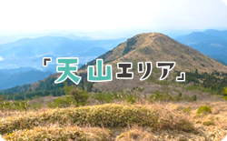
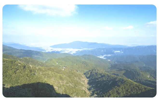
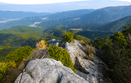
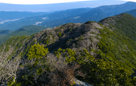
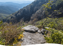
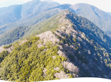
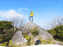
標高1054.6m、佐賀県神埼市と福岡県
福岡市との境に位置する『脊振山系』
最高峰である脊振山は、
昭和53(1978)年に日本山岳会から
日本三百名山の一つに選ばれました。
脊振山系一帯は、古くは霊山として
多くの修行僧が暮らす山岳仏教の修験場であり、今でもその痕跡が多く見られます。
この縦走コースは、脊振山をはじめとした
いくつかのピークを結んでおり、
所々岩場はあるものの、季節によっては
美しい植物も見ることができるため、
登山初心者でも楽しく登れる
コースとなっています。
昭和50(1975)年に脊振山系である
東の基山(404m)から
西方の浮嶽(805m)まで
約40kmにわたる尾根一体と北山ダム周辺を合わせて脊振北山県立自然公園に
指定されました。
![POINT](https://sagamichi.jp/wp-content/themes/sagamichi/plus/img/point.png)
◎標高1054.6mの脊振山系最高峰の山であり、日本三百名山の一つとなるコースは必見!
◎『鬼ヶ鼻岩』や『猟師岩山・唐人の舞』など、自然が織りなす“奇岩”を楽しもう!
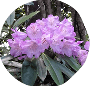
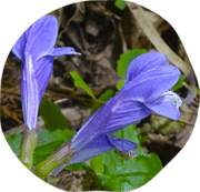
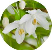
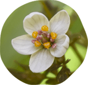
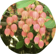
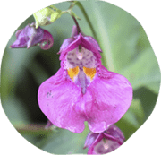
◎眺望の良いスポットが多く、春には『コバノミツバツツジ』や『ツクシシャクナゲ』、秋は『ブナ林』の紅葉に出会えることも!
![コースサマリー](https://sagamichi.jp/wp-content/themes/sagamichi/plus/img/course-summary.png)
![SPコースサマリー](https://sagamichi.jp/wp-content/themes/sagamichi/plus/img/course-summary_sp.png)
![初級](https://sagamichi.jp/wp-content/themes/sagamichi/plus/img/course1.png)
行 程:鬼ヶ鼻岩井出野登山口〜椎原峠西分岐〜鬼ヶ鼻岩(折り返し)〜鬼ヶ鼻岩井出野登山口
距 離:2㎞所要時間:2時間25分(休憩20分含む)[往路:75分・復路:50分]
![緩やかな勾配バナー](https://sagamichi.jp/wp-content/themes/sagamichi/plus/img/banner01.png)
![中級](https://sagamichi.jp/wp-content/themes/sagamichi/plus/img/course2.png)
行 程:鬼ヶ鼻岩井出野登山口〜椎原峠西分岐〜鬼ヶ鼻岩〜岩場上部の展望台/猟師岩〜 猟師岩山(折り返し)
〜鬼ヶ鼻岩井出野登山口
距 離:3.4㎞所要時間:3時間45分(休憩20分含む)[往路:115分・復路:90分]
![緩やかな勾配バナー](https://sagamichi.jp/wp-content/themes/sagamichi/plus/img/banner01.png)
![岩場ありバナー](https://sagamichi.jp/wp-content/themes/sagamichi/plus/img/banner02.png)
![急勾配ありバナー](https://sagamichi.jp/wp-content/themes/sagamichi/plus/img/banner03.png)
![](https://sagamichi.jp/wp-content/themes/sagamichi/plus/img/course3.png)
行 程:鬼ヶ鼻岩井出野登山口〜椎原峠西分岐〜鬼ヶ鼻岩〜岩場上部の展望台/猟師岩〜 猟師岩山(折り返し)
〜椎原峠西分岐〜唐人の舞〜白砂の広場〜脊振山・脊振神社(折り返し)〜鬼ヶ鼻岩井出野登山口
距 離:12.6㎞所要時間:7時間45分(休憩20分含む)[往路:185分・復路:260分]
![緩やかな勾配バナー](https://sagamichi.jp/wp-content/themes/sagamichi/plus/img/banner01.png)
![岩場ありバナー](https://sagamichi.jp/wp-content/themes/sagamichi/plus/img/banner02.png)
![急勾配ありバナー](https://sagamichi.jp/wp-content/themes/sagamichi/plus/img/banner03.png)
![マイマップ](https://sagamichi.jp/wp-content/themes/sagamichi/plus/img/map-title.png)
![SPマイマップ](https://sagamichi.jp/wp-content/themes/sagamichi/plus/img/sp-map.png)
本マイマップは、GPS受信で得られた連続した位置情報を元に線を作成しております。
コースを歩かれる際はお手持ちの地図に加え、実際の歩道標識を確認して歩くようにしましょう。
Googleマイマップ内にて写真の登録者として表示される和泉昌憲さんは、佐賀県が依頼した360°、及びスチルフォトグラファーです。
![ハイキング前後のお立ち寄りスポット](https://sagamichi.jp/wp-content/themes/sagamichi/plus/img/challenge.png)
![全コースここからスタート](https://sagamichi.jp/wp-content/themes/sagamichi/plus/img/start.png)
アクセス
- ■車利用 :
吉野山キャンプ場に駐車ください。(収容台数80台程度)
佐賀市内より50分、唐津市内より1時間
※スタート地点の鬼ヶ鼻岩井手野登山口まで徒歩30分 - ■公共交通機関 :
JR「神埼駅」よりジョイックス交通(バス)「三瀬神埼線」で三瀬支所まで約40分
→三瀬支所より松原タクシーで約10分 - ※松原タクシー TEL:0952-63-0002
![井手野の金山脊振林道登山口(鬼ヶ鼻岩)駐車場イメージ](https://sagamichi.jp/wp-content/themes/sagamichi/plus/img/box-image1.png)
![ビギナー、お手軽ハイキングを楽しみたい方向け!](https://sagamichi.jp/wp-content/themes/sagamichi/plus/img/sp-course1.png)
![ビギナー、お手軽ハイキングを楽しみたい方向け!](https://sagamichi.jp/wp-content/themes/sagamichi/plus/img/under-course_title01-pop.png)
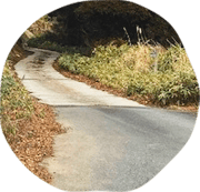
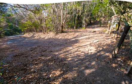
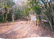
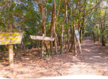
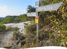
脊振山ハイキングコースの起点となることが多いスポット。九州自然歩道「脊振山エリア」のスタート地点となる「椎原峠西」へは徒歩30分ほど林道を登りましょう。
![ツクシシャクナゲイメージ](https://sagamichi.jp/wp-content/themes/sagamichi/plus/img/flower1.png)
![ツクシシャクナゲ](https://sagamichi.jp/wp-content/themes/sagamichi/plus/img/f-title.png)
![木のイラスト](https://sagamichi.jp/wp-content/themes/sagamichi/plus/img/tree.png)
![井手野の金山背振林道登山口イメージ1](https://sagamichi.jp/wp-content/themes/sagamichi/plus/img/ci1.png)
![井手野の金山背振林道登山口イメージ2](https://sagamichi.jp/wp-content/themes/sagamichi/plus/img/ci2.png)
![井手野の金山背振林道登山口イメージ3](https://sagamichi.jp/wp-content/themes/sagamichi/plus/img/ci3.png)
![徒歩約30分](https://sagamichi.jp/wp-content/themes/sagamichi/plus/img/time1.png)
![徒歩約30分](https://sagamichi.jp/wp-content/themes/sagamichi/plus/img/30.png)
![02椎原峠西地点](https://sagamichi.jp/wp-content/themes/sagamichi/plus/img/course-title02.png)
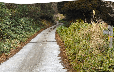
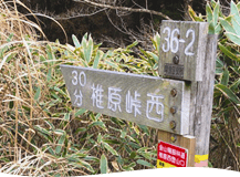
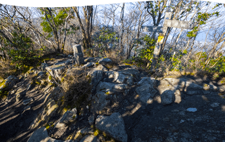
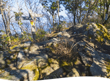
九州自然歩道「脊振山エリア」のスタート地点の一つであり、西は鬼ヶ鼻岩・猟師岩山、東は唐人の舞・脊振山に向かう地点になります。
![アオバト鳴き声イメージ](https://sagamichi.jp/wp-content/themes/sagamichi/plus/img/voice.png)
![アオバトイメージ](https://sagamichi.jp/wp-content/themes/sagamichi/plus/img/bird.png)
![アオバト](https://sagamichi.jp/wp-content/themes/sagamichi/plus/img/bird-name.png)
![椎原峠西地点イメージ1](https://sagamichi.jp/wp-content/themes/sagamichi/plus/img/ci4.png)
![椎原峠西地点イメージ2](https://sagamichi.jp/wp-content/themes/sagamichi/plus/img/ci5.png)
![椎原峠西地点イメージ3](https://sagamichi.jp/wp-content/themes/sagamichi/plus/img/ci6.png)
![徒歩約45分](https://sagamichi.jp/wp-content/themes/sagamichi/plus/img/time2.png)
![徒歩約45分](https://sagamichi.jp/wp-content/themes/sagamichi/plus/img/45.png)
![鬼ヶ鼻岩イメージ1](https://sagamichi.jp/wp-content/themes/sagamichi/plus/img/ci7.png)
![鬼ヶ鼻岩イメージ2](https://sagamichi.jp/wp-content/themes/sagamichi/plus/img/ci8.png)
![鬼ヶ鼻岩イメージ3](https://sagamichi.jp/wp-content/themes/sagamichi/plus/img/ci9.png)
![雄大な景観](https://sagamichi.jp/wp-content/themes/sagamichi/plus/img/plus-text1.png)
![03鬼ヶ鼻岩](https://sagamichi.jp/wp-content/themes/sagamichi/plus/img/course-title03.png)
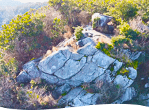
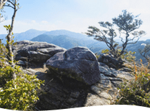
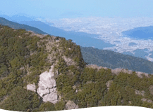
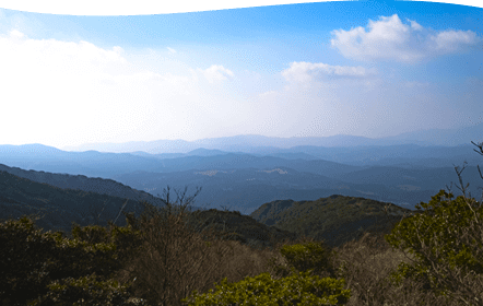
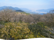
福岡と佐賀の県境にあり、脊振山系では最も大きな岩場の山。
福岡側の岩場は100mの断崖絶壁になっており、ロッククライミングの懸垂下降の練習の場にもなっています。
![ラショウモンカズライメージ](https://sagamichi.jp/wp-content/themes/sagamichi/plus/img/flower2.png)
![ラショウモンカズラ](https://sagamichi.jp/wp-content/themes/sagamichi/plus/img/f-title2.png)
![エゴノギイメージ](https://sagamichi.jp/wp-content/themes/sagamichi/plus/img/flower3.png)
![エゴノギ](https://sagamichi.jp/wp-content/themes/sagamichi/plus/img/f-title3.png)
![鳥イラスト](https://sagamichi.jp/wp-content/themes/sagamichi/plus/img/illust-bird.png)
![鬼ヶ鼻岩イメージ1](https://sagamichi.jp/wp-content/themes/sagamichi/plus/img/ci7.png)
![鬼ヶ鼻岩イメージ2](https://sagamichi.jp/wp-content/themes/sagamichi/plus/img/ci8.png)
![鬼ヶ鼻岩イメージ3](https://sagamichi.jp/wp-content/themes/sagamichi/plus/img/ci9.png)
![初級はここで折り返し!](https://sagamichi.jp/wp-content/themes/sagamichi/plus/img/term.png)
![初級はここで折り返し!](https://sagamichi.jp/wp-content/themes/sagamichi/plus/img/under-sp1.png)
![ここから中級!](https://sagamichi.jp/wp-content/themes/sagamichi/plus/img/middle.png)
![ハイキングをしっかり楽しみたい方向け!](https://sagamichi.jp/wp-content/themes/sagamichi/plus/img/sp-course2.png)
![ハイキングをしっかり楽しみたい方向け!](https://sagamichi.jp/wp-content/themes/sagamichi/plus/img/pop2.png)
![息をのむ景色](https://sagamichi.jp/wp-content/themes/sagamichi/plus/img/voice2.png)
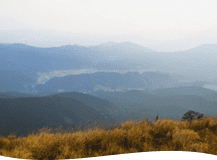
切り立った斜面にある岩の上からは、北に椎原の集落、遠くは福岡市内、東に脊振山への山並みなど大パノラマを楽しむことができます。
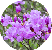
周囲には色とりどりのツツジ類、シャクナゲなどが自生し、春には多くの人が集います。
特に大輪の花を咲かせるシャクナゲはあなたの疲れを癒やしてくれること間違いなし!
![家のイラスト](https://sagamichi.jp/wp-content/themes/sagamichi/plus/img/illust-house.png)
![岩場上部の展望台イメージ1](https://sagamichi.jp/wp-content/themes/sagamichi/plus/img/ci10.png)
![岩場上部の展望台イメージ2](https://sagamichi.jp/wp-content/themes/sagamichi/plus/img/ci11.png)
![岩場上部の展望台イメージ3](https://sagamichi.jp/wp-content/themes/sagamichi/plus/img/ci12.png)
![徒歩約20分](https://sagamichi.jp/wp-content/themes/sagamichi/plus/img/time4.png)
![徒歩約20分](https://sagamichi.jp/wp-content/themes/sagamichi/plus/img/20.png)
![05猟師岩山](https://sagamichi.jp/wp-content/themes/sagamichi/plus/img/course-title05.png)
福岡市と佐賀市の境界にあり、標高は893.3m。春の沿道ではコバノミツバツツジやシャクナゲなどといった植物も探してみましょう。
![コバノミツバツツジイメージ](https://sagamichi.jp/wp-content/themes/sagamichi/plus/img/f5-1.png)
![コバノミツバツツジ](https://sagamichi.jp/wp-content/themes/sagamichi/plus/img/f5-11.png)
![ホオジロ鳴き声イメージ](https://sagamichi.jp/wp-content/themes/sagamichi/plus/img/fvoice.png)
![ホオジロイメージ](https://sagamichi.jp/wp-content/themes/sagamichi/plus/img/f5-2.png)
![ホオジロ](https://sagamichi.jp/wp-content/themes/sagamichi/plus/img/f5-22.png)
![猟師岩山イメージ1](https://sagamichi.jp/wp-content/themes/sagamichi/plus/img/ci13.png)
![猟師岩山イメージ2](https://sagamichi.jp/wp-content/themes/sagamichi/plus/img/ci14.png)
![猟師岩山イメージ3](https://sagamichi.jp/wp-content/themes/sagamichi/plus/img/ci15.png)
![中級コースはここで折り返し!](https://sagamichi.jp/wp-content/themes/sagamichi/plus/img/term2.png)
![中級コースはここで折り返し!](https://sagamichi.jp/wp-content/themes/sagamichi/plus/img/under-sp2.png)
![上級コースへのチャレンジは早朝の出発がおすすめ!](https://sagamichi.jp/wp-content/themes/sagamichi/plus/img/sp-course3.png)
![上級コースへのチャレンジは早朝の出発がおすすめ!](https://sagamichi.jp/wp-content/themes/sagamichi/plus/img/pop3.png)
その昔、唐の人がこの地を訪れた時、眺めの素晴らしさに驚き、遠くの故郷を偲んで、石の上で踊ったという言い伝えから名付けられたそう。おにぎり型の巨岩の上から福岡市街や博多湾が一望できます。
![サバノオイメージ](https://sagamichi.jp/wp-content/themes/sagamichi/plus/img/flower4.png)
![サバノオ](https://sagamichi.jp/wp-content/themes/sagamichi/plus/img/ftitle4.png)
![ベニドウダンイメージ](https://sagamichi.jp/wp-content/themes/sagamichi/plus/img/flower5.png)
![ベニドウダン](https://sagamichi.jp/wp-content/themes/sagamichi/plus/img/ftitle5.png)
![唐人の舞イメージ1](https://sagamichi.jp/wp-content/themes/sagamichi/plus/img/ci16.png)
![唐人の舞イメージ2](https://sagamichi.jp/wp-content/themes/sagamichi/plus/img/ci17.png)
![唐人の舞イメージ3](https://sagamichi.jp/wp-content/themes/sagamichi/plus/img/ci18.png)
![徒歩約30分](https://sagamichi.jp/wp-content/themes/sagamichi/plus/img/time1.png)
![徒歩約30分](https://sagamichi.jp/wp-content/themes/sagamichi/plus/img/30.png)
![ランチスポット](https://sagamichi.jp/wp-content/themes/sagamichi/plus/img/plus-text2.png)
![07白砂の広場](https://sagamichi.jp/wp-content/themes/sagamichi/plus/img/course-title07.png)
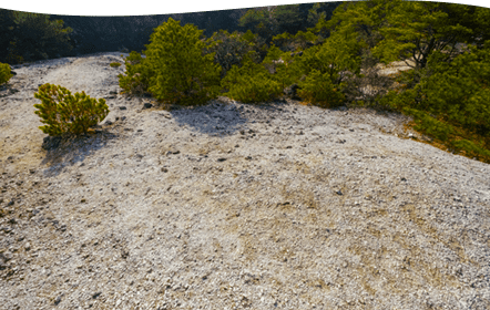
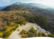
日本庭園の雰囲気を感じることができる花崗岩が風化して砂に変わった県内でも珍しい場所。
広場になっているため、休憩やランチスポットとされることが多く、春にはコバノミツバツツジの花のトンネルが出迎えてくれます。
![アオバト鳴き声イメージ](https://sagamichi.jp/wp-content/themes/sagamichi/plus/img/bird-voice.png)
![アオバトイメージ](https://sagamichi.jp/wp-content/themes/sagamichi/plus/img/bird2.png)
![アオバト](https://sagamichi.jp/wp-content/themes/sagamichi/plus/img/bird-name.png)
![白砂の広場イメージ1](https://sagamichi.jp/wp-content/themes/sagamichi/plus/img/ci19.png)
![白砂の広場イメージ2](https://sagamichi.jp/wp-content/themes/sagamichi/plus/img/ci20.png)
![白砂の広場イメージ3](https://sagamichi.jp/wp-content/themes/sagamichi/plus/img/ci21.png)
![徒歩約40分](https://sagamichi.jp/wp-content/themes/sagamichi/plus/img/time6.png)
![徒歩約40分](https://sagamichi.jp/wp-content/themes/sagamichi/plus/img/40.png)
![脊振山・脊振神社イメージ1](https://sagamichi.jp/wp-content/themes/sagamichi/plus/img/ci22.png)
![脊振山・脊振神社イメージ2](https://sagamichi.jp/wp-content/themes/sagamichi/plus/img/ci23.png)
![脊振山・脊振神社イメージ3](https://sagamichi.jp/wp-content/themes/sagamichi/plus/img/ci24.png)
![08脊振山・脊振神社](https://sagamichi.jp/wp-content/themes/sagamichi/plus/img/course-title08.png)
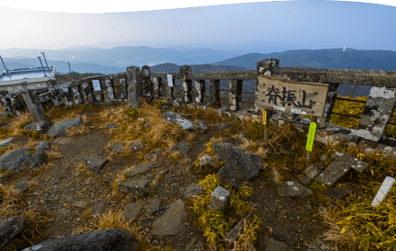
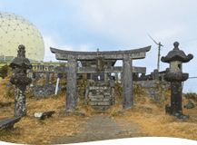
福岡と佐賀の県境を東西に走る、標高1,054.6mの脊振山系最高峰の山。英彦山より古いとされる山岳仏教の修験場であり、中宮とされる霊仙寺は日本茶栽培の発祥の地とも伝えられています。脊振山の山頂に鎮座する脊振山上宮大弁財天と下宮の脊振神社は「脊振弁財天」と称され、日本六所弁財天の一社とされます。
![ツリフネソウイメージ](https://sagamichi.jp/wp-content/themes/sagamichi/plus/img/flower6.png)
![ツリフネソウ](https://sagamichi.jp/wp-content/themes/sagamichi/plus/img/flower-name.png)
![オオカメノキイメージ](https://sagamichi.jp/wp-content/themes/sagamichi/plus/img/flower7.png)
![オオカメノキ](https://sagamichi.jp/wp-content/themes/sagamichi/plus/img/flower-name2.png)
![脊振山・脊振神社イメージ1](https://sagamichi.jp/wp-content/themes/sagamichi/plus/img/ci22.png)
![脊振山・脊振神社イメージ2](https://sagamichi.jp/wp-content/themes/sagamichi/plus/img/ci23.png)
![脊振山・脊振神社イメージ3](https://sagamichi.jp/wp-content/themes/sagamichi/plus/img/ci24.png)
![背振山イラスト](https://sagamichi.jp/wp-content/themes/sagamichi/plus/img/illust-tent.png)
![上級コースはここで折り返し!](https://sagamichi.jp/wp-content/themes/sagamichi/plus/img/term3.png)
![上級コースはここで折り返し!](https://sagamichi.jp/wp-content/themes/sagamichi/plus/img/under-sp3.png)
![周辺情報](https://sagamichi.jp/wp-content/themes/sagamichi/_assets/img/page/tenzan/neighborhood_title01.png)
※新型コロナウイルスの感染状況により、
各施設営業時間の変更が予想されます。
ご利用の際は、事前にご確認ください。
-
本マイマップは、GPS受信で得られた連続した位置情報を元に線を作成しております。
コースを歩かれる際はお手持ちの地図に加え、実際の歩道標識を確認して歩くようにしましょう。
Googleマイマップ内にて写真の登録者として表示される和泉昌憲さんは、佐賀県が依頼した360°、及びスチルフォトグラファーです。 -
-
福岡と佐賀を結ぶ国道沿いにあることから、週末は警備員が駐車場を誘導するほどの盛況ぶり。 店内にはイートインコーナーも充実しゆっくりランチを楽しむこともできる。
【住所】
佐賀市三瀬村杠字浦田657-4
【車でのアクセス】
佐賀市中心部より50分
唐津市中心部より1時間10分
●吉野山キャンプ場より10分
【電話】0952-56-2739 -
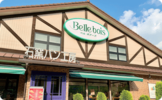
ドイツの香り漂う雰囲気の店舗では毎朝ハムやソーセージが燻製にされ販売されている。新テラス『Cafe Brat wurst』ではガラス張りのヨーロッパ風カフェになっており、ランチにおすすめ。
【住所】
佐賀県佐賀市三瀬村藤原3796-3
【車でのアクセス】
佐賀市中心部より50分
唐津市中心部より1時間20分
●吉野山キャンプ場より10分
【電話】0952-56-2781
【WEB】http://hamsausage-ibusuki.com -
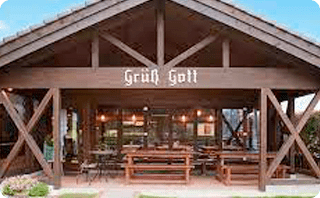
佐賀県のお蕎麦屋さんでミシュランガイドに記載されている4軒のうちの一つ。木のぬくもりを感じられる店内で店主のこだわりぬいたお蕎麦を味わうことができる。
【住所】
佐賀県神埼市脊振町服巻5760
【車でのアクセス】
佐賀市中心部より40分
唐津市中心部より1時間30分
●吉野山キャンプ場より20分
【電話】0952-65-3250 -
溶岩窯で一気に高温で焼き上げるピザやチキン、ハンバーググリルはリピーター続出!お店の外にはテラス席もあり、天気の良い日は外でゆっくりしたい。テイクアウトも可能◎
【住所】
佐賀県神埼市脊振町服巻2310-36
【車でのアクセス】
佐賀市中心部より50分
唐津市中心部より1時間30分
●吉野山キャンプ場より15分
【電話】0952-65-4778
【WEB】 https://www.bleucouronne.com -
山奥の隠れ家的なカフェでありながら解放感とぬくもりのある空間が特徴。オーガニック野菜と自然素材でで育てられた鶏肉を使った料理がおススメ!
【住所】
佐賀県佐賀市三瀬村三瀬藤原33-75
【車でのアクセス】
佐賀市中心部より50分
唐津市中心部より1時間10分
●吉野山キャンプ場より5分
【電話】0952-56-2181
【WEB】 https://m.facebook.com/profile.php?id=866807706992104
-
-
-
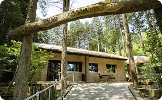
美しい紅葉で知られる国の名勝・九年庵は9年の歳月をかけて築かれたことが名前の由来。数寄屋造りの邸宅と筑紫平野を借景にした庭園は、紅葉が美しい秋と新緑に癒される春に一般公開されている。
【住所】
佐賀県神埼市神埼町的1696
【車でのアクセス】
佐賀市中心部より30分
唐津市中心部より1時間40分
●吉野山キャンプ場より30分
【電話】0952-37-0107
(神埼市商工観光課) -
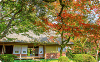
JR神崎駅より車で15分の場所にある城原川にかかる市の重要文化財になっている橋。春になると眼鏡橋の周囲の川沿いに約2kmに桜が咲き、お花見スポットしても人気◎
【住所】
佐賀県神埼市脊振町広滝県道21−号線付近
【車でのアクセス】
佐賀市中心部より30分
唐津市中心部より1時間40分
●吉野山キャンプ場より25分
【電話】0952-37-0107
(神埼市商工観光課) -
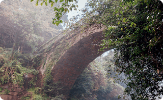
標高約450mの三瀬高原に位置する、約75万平米もの広大な草原にある動物エリアや、パン工房、おみやげ屋、ワイン館、レストランなどは家族連れもおススメ!
【住所】
佐賀県佐賀市三瀬村杠2234-67
【車でのアクセス】
佐賀市中心部より50分
唐津市中心部より1時間10分
●吉野山キャンプ場より15分
【電話】0952-56-2141
【WEB】https://www.dongurimura.com
-
-
-
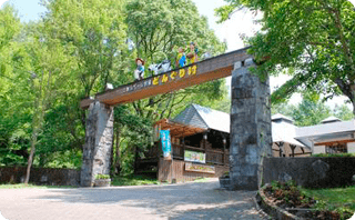
三瀬村や富士町特有の高冷地栽培で育てられたこだわりの食材を販売する直売所。お弁当やお惣菜なども販されており、ハイキング前に立ち寄って購入も可能!
【住所】
佐賀県佐賀市三瀬村杠246-1
【車でのアクセス】
佐賀市中心部より50分
唐津市中心部より1時間10分
●吉野山キャンプ場より10分
【電話】0952-56-2705
【WEB】http://www.macchan.co.jp
-
-
-
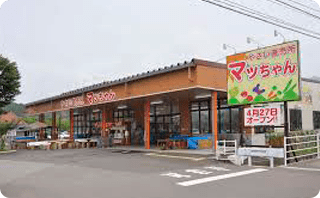
ゴール地点より車で20分ほどの場所にある、三瀬村の里山と温泉を楽しむことができる入浴施設。自然を満喫することができる露天風呂や、天井まで一面ガラス張りの開放感のある大浴場などがある。
【住所】
佐賀県佐賀市三瀬村藤原3929-2
【車でのアクセス】
佐賀市中心部より50分
唐津市中心部より1時間10分
●吉野山キャンプ場より10分
【電話】0952-56-2223
【WEB】https://www.souyu.co.jp/shisetsu/yamabiko
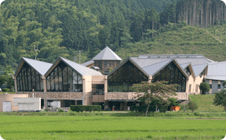
-